

Before the Snakes Reach the Summit: Why Margalla Must Be Saved
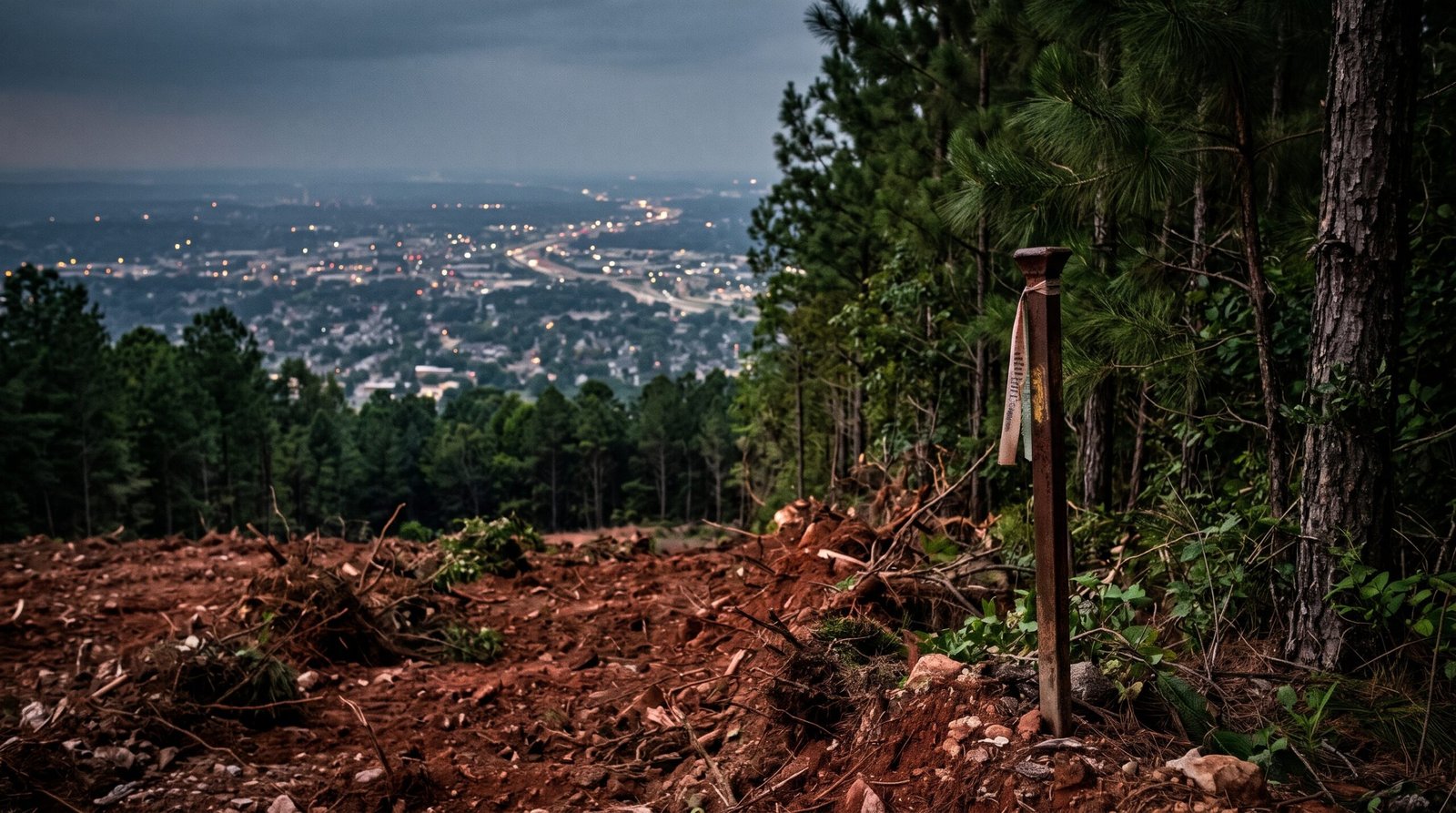
Every evening in Islamabad, the light goes soft over the Margalla Hills. The ridgeline turns blue, then grey, then dark, and the city’s lights come on beneath it. Residents rarely think about what they are looking at. They treat the hills as scenery, like the weather or the sky. But Margalla is not scenery. It is the reason Islamabad exists where it does, the reason the city can breathe, and the reason it is unlike any other capital in South Asia. It is now being eyed as real estate.
A Name With a Hundred Stories
Ask ten people in Islamabad where “Margalla” comes from and you will get ten answers. The most popular folk etymology splits the word in two: mar, meaning “snake” in Persian and Pashto, and galla, meaning “herd” or “gathering.” On this reading, Margalla is a place of many snakes, or more broadly a place teeming with wildlife. Scholars may argue over whether the derivation is sound, and folk etymologies are rarely tidy. But the story endures because it captures something true. These hills have always been a gathering place of living things: leopards and barking deer, goral on the cliffs, wild boar in the scrub, hundreds of bird species, and, yes, snakes in the undergrowth.
I want to borrow that old image for a darker purpose. The snakes of Margalla were never the real danger. The real danger is a different kind of serpent: the well-connected and well-capitalised, eyeing the slopes not as a forest but as a plot map. Property-hungry developers, with their patrons and their promises of “exclusive” hillside living for the elite, are circling a piece of the Margalla range. If the snakes of the folk tale were creatures of the hills, the new ones are creatures of the land registry. They are far more dangerous to the hills than any reptile.
From the Grand Trunk Road to the Raj
To understand what is at stake, we must begin with history. Long before there was an Islamabad, the Margalla Pass was one of the great gateways of the subcontinent. The old imperial road that later became the Grand Trunk Road squeezed through this natural cleft in the hills, carrying armies, traders, pilgrims and poets between the Indus plains and the Punjab. Nearby Taxila, whose Buddhist and Gandharan ruins now hold UNESCO World Heritage status, tells us that this landscape has been sacred, strategic and inhabited for more than two thousand years.
When the British annexed the Punjab in 1849, they understood the value of the terrain at once. Within a couple of years they had established a cantonment at Rawalpindi, which grew into one of the most important garrison towns of the Raj, the staging ground for the North-West Frontier. The hills above it were part of the strategic picture, and the pass was marked with an obelisk commemorating John Nicholson, the colonial officer who had campaigned in this country and died at Delhi in 1857. The monument, still standing at the pass, is an odd and ambiguous inheritance. One may or may not care for what it commemorates, but it is a reminder that the colonial state looked at these hills and saw something to be managed rather than consumed.
That is worth dwelling on. Whatever else colonial administrators did, and much of it was extractive, they also brought forest-reservation laws and a bureaucratic habit of classifying land. Scrub-covered slopes and watercourses were recorded in gazetteers and settlement papers as forest, grazing and catchment, not as vacant lots. The Raj cut down plenty of trees across the subcontinent, but its records also created a paper trail of protected status that later generations could invoke. It would be a bitter irony if a modern republic, a state founded on the promise of sovereignty over its own land, were to be less careful with that inheritance than the empire it replaced.
A Capital Built Around a Forest
When Pakistan’s government decided in the late 1950s to build a new capital, away from the heat and congestion of Karachi and close to the army’s headquarters in Rawalpindi, the choice of site was no accident. The hills mattered. The Greek planner Constantinos Doxiadis laid out a grid of sectors descending from the Margalla foothills, with green belts and the hills themselves as a northern backdrop. The Capital Development Authority was created in 1960 to build the city. The idea was explicit: Islamabad would be a planned, green capital, with the Margallas as its crown.
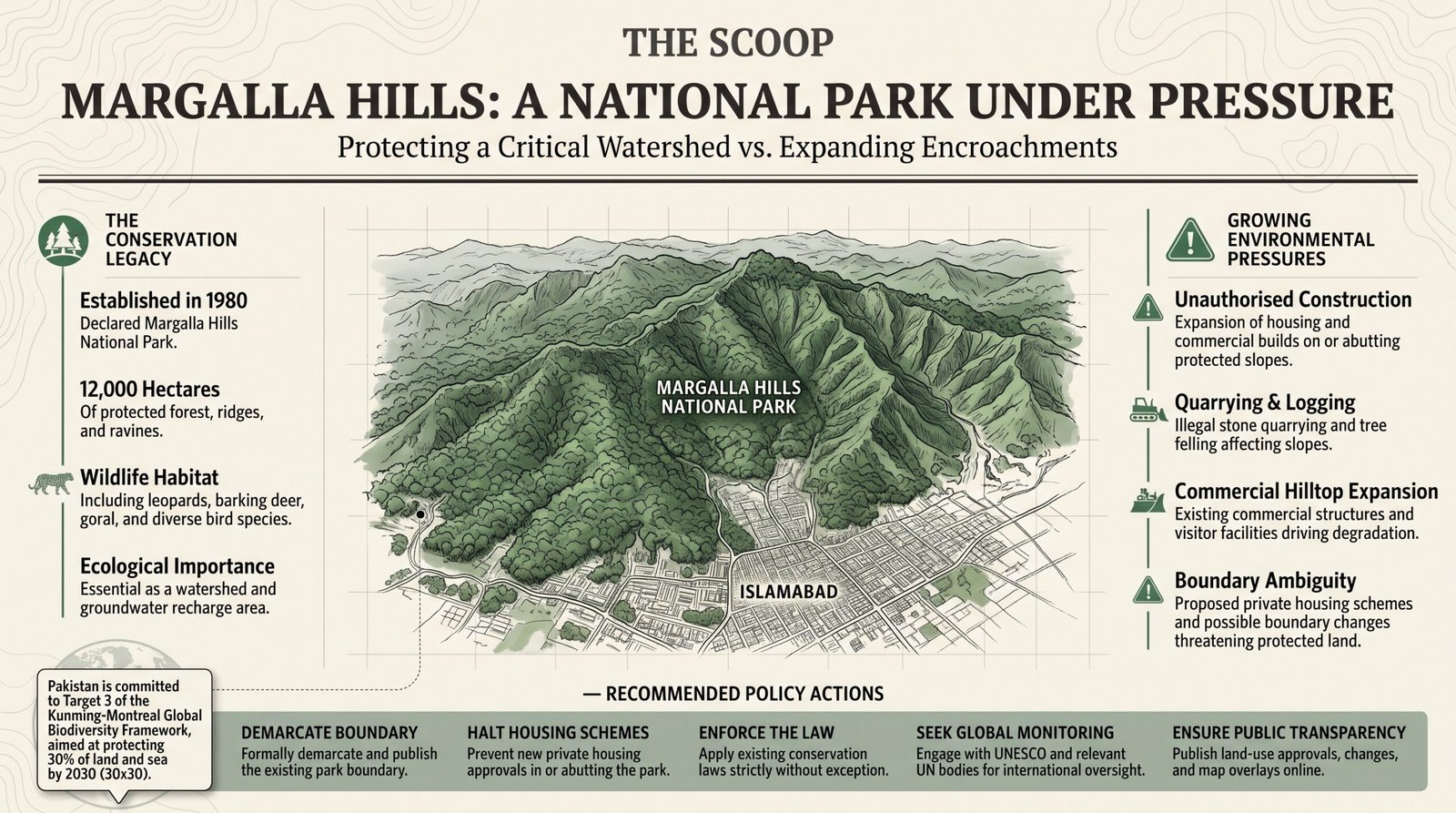
In 1980 the government formalised that idea by declaring the Margalla Hills National Park, covering roughly twelve thousand hectares of forest, ridge and ravine. The designation recognised what ecologists already knew. The hills hold subtropical pine and scrub forest, they shelter a remarkable range of mammals and birds within sight of a capital of millions, and they are one of the very few places in the world where wild leopards still move along the edge of a national capital’s suburbs.
The Lungs and the Sponge
Islamabad’s residents like to call Margalla the city’s lungs, and the metaphor is more literal than most. Forested hills filter dust, moderate temperatures and feed cleaner air down into the valley. In a country that now regularly ranks among the most polluted in the world, and where winter smog has become a seasonal fact of life across the Punjab, a forested ridge is not a luxury. It is public health infrastructure.
The hills are also a sponge. Their slopes catch monsoon rain and release it slowly into streams, springs and the catchment of Rawal Lake, which supplies drinking water to Islamabad and Rawalpindi. Remove the vegetation, cut roads across the slopes, pour concrete over the recharge zones, and the same rain stops soaking in and starts rushing down. The result is flash flooding in the nullahs below, erosion on the hillsides and a falling water table. Pakistan has just lived through a series of floods and heat waves that should have ended any argument about the value of natural buffers. A hillside home with a view is worth a lot to the one who buys it. A watershed is worth more to a million who live downstream.
Then there is the plain matter of life. A leopard needs space and prey. Cut the forest into gated enclaves and fenced villas, and you do not simply remove habitat. You trap animals in islands, push them toward homes and create the conflict that ends with a dead animal and a public outcry. Every encroachment is also a promise of a future tragedy.
What the Numbers Actually Say
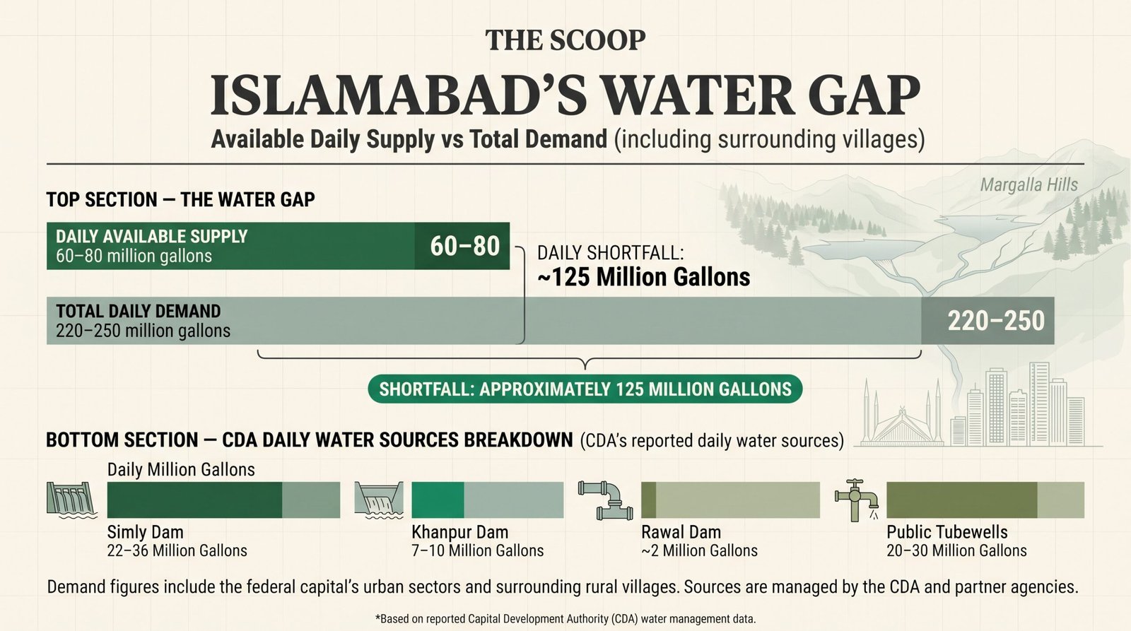
It is worth being precise here, because the case for Margalla is strong enough that it does not need exaggeration. Islamabad does not drink straight from the hills. The city’s piped supply comes mainly from Simly Dam, Khanpur Dam, a network of public tubewells and, in a small way, Rawal Dam. According to CDA figures reported over the past few years, Simly typically delivers somewhere between 22 and 36 million gallons a day, depending on the season and the reservoir level. Khanpur contributes roughly 7 to 10 million. Rawal Dam adds only about 2 million, though the CDA chairman has recently spoken of around 5. The tubewells contribute another 20 to 30 million. In total, the authority supplies about 60 to 80 million gallons daily.
Against that, demand is enormous. The CDA puts the need of the urban areas at around 120 million gallons a day, and the needs of the capital as a whole, including its villages, at 220 to 250 million. The chairman told a Senate committee in August 2026 that the shortfall stands at about 125 million gallons a day. Residents fill the gap with private bores, tankers and rationing. The irony is that Islamabad receives somewhere between 1,100 and 1,300 millimetres of rain a year, yet much of it runs off through the nullahs, because the city has almost nowhere to store it.
So how much of this water comes “out of the Margalla Hills”? The honest answer is that nobody has published a single reliable figure, and anyone who offers one is guessing. Simly is fed by the Soan and the Murree hills, and Khanpur by the Haro basin; neither is a Margalla dam. What the hills do provide is quieter and arguably more important:
- Rawal Lake. The lake is formed by the Korang River together with small streams descending from the Margalla Hills. It is the reservoir from which the twin cities draw, and the committee that reviewed Margalla Hills National Park a few years ago found sewage entering its feeder streams as a serious health risk.
- The groundwater of the twin cities. The roughly 20 to 30 million gallons a day pumped from tubewells, along with the private bores that quietly cover much of the remaining gap, draw on aquifers recharged by rain that falls on, and seeps through, the Margalla slopes and foothills. Hydrogeological studies of the area describe the hills’ many streams as a major source of surface runoff for groundwater recharge. What happens to the hills therefore decides what comes out of the ground on both sides of the capital’s boundary, in Islamabad and in neighbouring Rawalpindi. The wildlife board reported in 2022 that heavy rains and better protection had revived dried springs on the hiking trails, and that the park’s aquifer had filled to its fullest.
- The streams and springs themselves. Around two dozen streams run through the capital, most of them rising in or below the hills. Around Pir Sohawa and the Saidpur area, natural watercourses such as the Saidpur Kas and the runoff channels around it have for generations served local irrigation and drinking needs. Villages such as Saidpur have long depended on them, and complained for years about hotel and sewage run-off fouling that water.
- Saidpur Water Works. The local supply infrastructure is not an abstraction either. Saidpur Water Works operates under the Water Supply Directorate of the CDA’s Engineering Wing, which manages water production, treatment and distribution in the area. A public utility built on a hill stream is itself a reason to protect the watershed above it: every plot cleared upstream raises the cost of treating the water downstream, and that cost falls on the public purse.
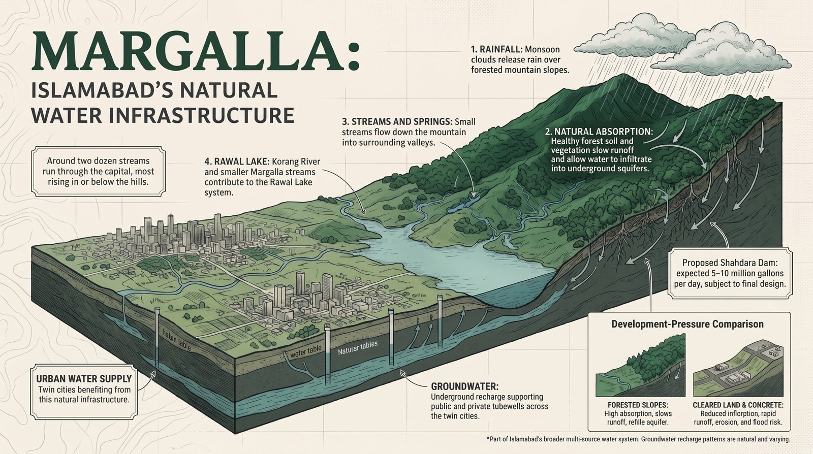
The most telling detail may be the newest. In the past two weeks the CDA has floated a tender for Shahdara Dam, on a Margalla stream, which would be the first new source added to the city’s system in almost thirty years. It is expected to give 5 to 10 million gallons a day, subject to final design. The authority also plans four check dams at the foothills, near D-12, Shah Allah Ditta and Saidpur. In other words, a water-starved capital is now turning to the Margalla catchment for its next drops. That is precisely why the catchment cannot be paved over.
The arithmetic is simple. When a city is short of more than half its water, every spring, stream and recharge zone is an asset it cannot afford to lose. Housing schemes on the slopes would replace porous forest soil with roofs and roads, send the rain away as flood instead of storing it underground, and add sewage to streams that are already too polluted. We would be selling off the catchment to build luxury homes for a few, while the many queue for tankers.
Not a New Fight, but a Persistent One
None of this is hypothetical. For decades, Margalla has been nibbled at: unauthorised construction, hilltop restaurants, quarrying, illegal tree felling, private housing schemes that blur the boundary of what is “park” and what is not. The country’s own judiciary has intervened more than once. In recent years the Supreme Court has ordered action against construction inside the national park, including a landmark case that led to the sealing and demolition of commercial structures on the hills. Courts, activists, journalists and ordinary hikers have defended the hills year after year, and each time it has taken extraordinary effort for what should be a simple principle: a national park is not for sale.
The trouble is that every such victory is temporary. A ruling can be diluted, a notification amended, a boundary redrawn. Pressure for elite housing does not go away. It simply waits for a change of officials, a change of mood, a quiet reclassification of a few hundred acres from “forest” to “development.” One by one, the exceptions become the rule.
Why the World Should Care
It might be tempting to say this is a purely domestic matter, and in the narrow sense of sovereignty it is. But the world has a stake, and the world has tools.
Pakistan is party to the Convention on Biological Diversity and has endorsed the global goal of protecting thirty per cent of land and sea by 2030. A national park on the edge of a capital city is precisely the sort of site such commitments are meant to protect, and precisely the sort that tends to be sacrificed first. Pakistan already has UNESCO World Heritage sites, including Taxila just beyond the hills, so it knows what international recognition can mean. UNESCO’s programmes, from biosphere reserve status to technical support for conservation planning, offer a framework that could give Margalla a layer of protection beyond the reach of any single government’s changing priorities. The United Nations Environment Programme and the global conservation community can contribute expertise, monitoring and, just as importantly, scrutiny. Satellite imagery now makes quiet land-grabs visible to anyone who is looking, and international attention makes them politically costly.
I am not suggesting foreign institutions should override Pakistani law. I am suggesting that when a country’s own protections prove fragile, shared global frameworks can serve as a second lock on the door. Pakistan’s government, if it is sincere about its climate and biodiversity pledges, should welcome that help and should itself invite UNESCO and UN agencies to assess, recognise and monitor the hills.
What Should Be Done
First, the existing boundary of the Margalla Hills National Park should be demarcated on the ground, published, and made legally inviolable, with any change requiring open parliamentary debate and not a quiet notification. Second, no new private housing scheme should receive approval in or abutting the park, and any existing illegal structures should be dealt with under the law, without exception for the powerful. Third, Pakistan should formally seek international recognition and monitoring of the hills through UNESCO and the relevant UN bodies. Fourth, the public should be kept informed: maps, approvals and land-use changes in the hills should be published online, so that no one has to learn about a “project” from the sound of bulldozers.
The Last Green Wall
A capital city is a statement of what a country values. Islamabad was conceived as a city in a forest, a modern capital that honoured its landscape. If its founding idea survives only on a tourist brochure, the loss will not be only environmental. It will be a loss of faith that anything in this country can be held in trust for everyone rather than carved up for a few.
The hills have been standing since long before the Raj, long before the cantonment and the Grand Trunk Road, and long before anyone drew a sector map. They will outlast the developers’ brochures too, if we let them. The snakes of the old etymology belonged to the hills. The ones now circling the slopes, with their maps and their money, do not. It is the duty of Pakistanis, and of a global community that claims to care about the planet, to make sure that the lungs of Islamabad keep breathing.
Disclaimer: The views and opinions expressed in this article are solely those of the author(s) and do not necessarily reflect the editorial position, values or beliefs of The Scoop or its management.
The Scoop firmly believes in freedom of speech, intellectual diversity and the open exchange of ideas. As an independent media platform, we remain committed to providing space for differing perspectives, including those that may challenge or contradict our own views.
Publication does not constitute endorsement. Our commitment to freedom of expression and independent journalism extends beyond opinions with which we agree.